Housing Plan Strategy Map
As part of updating our housing policies, the City needed to determine where future housing should be located and what it should look like once built. In November 2014, the City hosted a series of Community Dialogue Sessions and used an online engagement tool to solicit community-specific input. People who live and work in Encinitas were asked to share their thoughts about how they define community character, what characteristics they want to preserve, and what characteristics they want to introduce. They were also asked for their input on locations in each community that would be appropriate for future housing and what that housing should look like. Because each of the five Encinitas communities has its own identity, a “one size fits all” approach to developing a housing plan will not work. Instead the plan approach relies on community-endorsed solutions to create a tailored plan to fit the unique character of each community.
Extensive community input was used to develop different housing strategies that identify locations for future housing in each community. Clear themes emerged from this input, along with insights into other issues to further strengthen the quality of life we enjoy in Encinitas. Each of the strategies developed has a different focus and mix of sites to accommodate the community’s future housing needs. Based on the totality of public input and the environmental review process, the Sustainable Mixed Use Places housing strategy map was selected to be forwarded to the voters for consideration in November 8, 2016 ballot. The Environmental Assessment/Program Environmental Impact Report (EIR) found this plan to be the Environmentally Superior Alternative. The EIR also found that this map best achieves the project objectives.
Sustainable Mixed Use Places/Environmentally Superior Alternative
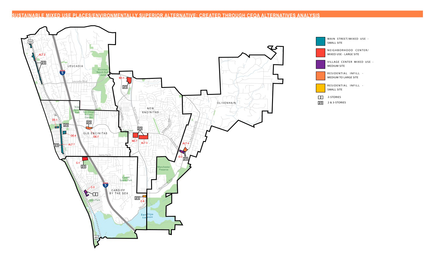 The Sustainable Mixed Use Places housing strategy map represents an alternative to the housing strategies addressed as the project in the At Home in Encinitas Environmental Impact Report. It is an alternative that refines, but would have fewer impacts than the project’s Modified Mixed Use Places strategy, which was developed in response to substantial public input. The Sustainable Mixed Use Places map has also been identified as the Environmentally Superior Alternative. This plan is the most compatible with community character. It improves the feasibility of transit service and supports walking and biking. New development is directed to areas that would benefit from the investment. Coastal mixed use business districts are strengthened, while New Encinitas and Olivenhain gain opportunities for their own mixed use places.
All but one of the sites identified on the Sustainable Mixed Use Places housing strategy map would permit a mixture of housing types that could be built up to two and three stories. The exception is Viable Housing Site C-3, where building heights would be limited to two stories.
Approach
- Mixed-use in key activity centers
- Two- and three-story buildings
- Opportunities to grow employment base and small businesses
- Create walkable places and social gathering opportunities
- Address infrastructure needs
- Maintain unique character of communities
- Maintain small scale in built environment